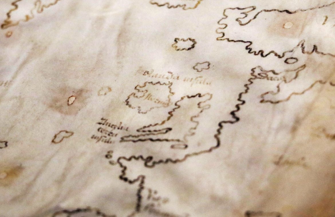
The map of Vinland has been considered one of the oldest representations of North America. Yale researchers have taken a closer look at a document that the Vikings were to make in the 15th century. After analyzing the ink, they announced that the map dates back to the 1920s. “The map of Vinland is wrong,” said Raymond Clemens, curator of early books and manuscripts at Yale University’s Beinecke Rare Book and Manuscript Library. The map has raised skepticism among historians for years. In an official comment on the scholars’ website, Clemens cut all speculations off. – No doubt about this. This new analysis should put an end to this issue – concluded the expert. According to research, the parchment is about 600 years old, and the ink itself contains large amounts of titanium and smaller amounts of barium, elements that were used in the production of pigments in the 1920s. Scholars believe that the map was deliberately fake. On the back of the manuscript there is an inscription linking the image to …
sought
comments (6)
1 hour ago
The fact that the map is fake does not change the fact that traces of Viking settlements have been found. The sentence “It was to be made by the Vikings in the fifteenth century” proves the level of this…Read everything
see more comments (6)

The fact that the map is fake does not change the fact that traces of Viking settlements have been found. The sentence “It was to be made by the Vikings in the 15th century” proves the level of this information.
In the 15th century, the Vikings were long gone.
blatant fraud…
21 minutes ago
In the 15th century, the last descendants of the Vikings still lived in Greenland. A bit of an author’s mental shortcut. On the other hand, the map is clearly a fake, as it does not resemble any of the medieval cartographic styles. The falsification can also be seen in the many “bays” off the coast of Britain – no sailor would have drawn a map of Britain so inaccurate with so many imaginary bays, geographers would have drawn a simplified map with smooth edges. The map is of similar value to the so-called “Chronicle of Prokosz”, which was also written for a joke in the 19th century.
The Vikings were the first white Europeans in America to find their settlement, so the textbooks should be rewritten because it was not Columbus who discovered them, but only them. Columbus only colonized what his ancestors could not manage due to the very small number that they got there.
They revealed that the turtles that support the world stand on elephants, and instead of elephants, turtles are put on a whale, and only aesthetic theory changed that.
Recent Comments (6)
blatant fraud…
21 minutes ago
In the 15th century, the last descendants of the Vikings still lived in Greenland. A bit of a mental shortcut to the author. On the other hand, the map is clearly a fake, as it does not resemble any of the medieval cartographic styles. The falsification can also be seen in the many “bays” off the coast of Britain – no sailor would have drawn a map of Britain so inaccurate with so many imaginary bays, geographers would have drawn a simplified map with smooth edges. The map is of similar value to the so-called “Chronicle of Prokosz”, which was also written for a joke in the 19th century.
They revealed that the turtles that support the world stand on elephants, and instead of elephants, turtles are put on a whale, and only aesthetic theory changed that.
In the 15th century, the Vikings were long gone.
The Vikings were the first white Europeans in America to find their settlement, so the textbooks should be rewritten because it was not Columbus who discovered them, but only them. Columbus only colonized what his ancestors could not manage due to the very small number that they got there.
The fact that the map is fake does not change the fact that traces of Viking settlements have been found. The sentence “It was to be made by the Vikings in the 15th century” proves the level of this information.
Of course this map must be wrong because it proves that in the north 1000 years ago the climate was much milder and warmer than it is today… It conflicts with current claims of a climate catastrophe, so this map cannot be considered correct. The fact is that this map is also original and is about 1000 years old, and 1000 years ago Greenland was a green island, and wild grapes grew on the modern Canadian Atlantic coast …

“Food practitioner. Music junkie. Avid troublemaker. Hipster-friendly creator. Social media lover. Wannabe pop culture fanatic.”