Some time ago I wrote about strong winds that were about to hit the western British Isles. It turns out that the previous hurricane Larry went as far north. Greenland and Iceland are in the path of the wide system, where strong winds and the first heavy snowstorms of the season will appear. Let’s see where Hurricane Larry is currently raging and what will happen in the coming days.
Hurricane Larry hit Canada
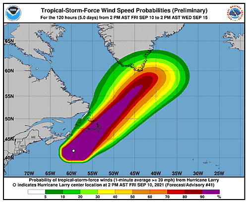
As I wrote in the introduction, the forecast has shifted Hurricane Larry to the north. So, the first hurricane hit Newfoundland, which is part of Canada. Larry was a Category 1 Saffir-Simpson phenomenon at the time of the landfall. This means gusts of more than 180 km/h as well as numerous storms and torrential rain. Below, the prediction path of the phenomenon (Source NOAA)
In the following stages, the cyclone turns into a tropical storm, and then hits Greenland as a tropical depression, which leads to a strong climatic breakdown in the region. The bad weather in Greenland will last about two weeks.
A breakdown in the weather in Greenland and Iceland
Some time ago I wrote about an anomaly of very high temperatures in Greenland. I was worried about him melting iceWhere the temperatures in the described area reached 23 degrees. For the time being, the situation on the glacier would return to normal. It is worth noting that the collapse of weather caused by former Hurricane Larry will bring huge snowstorms in Greenland. In the next two weeks, new snow may fall on the island from 1.5 to 2 meters. However, not only blizzards will be a problem when exposed to a tropical depression.
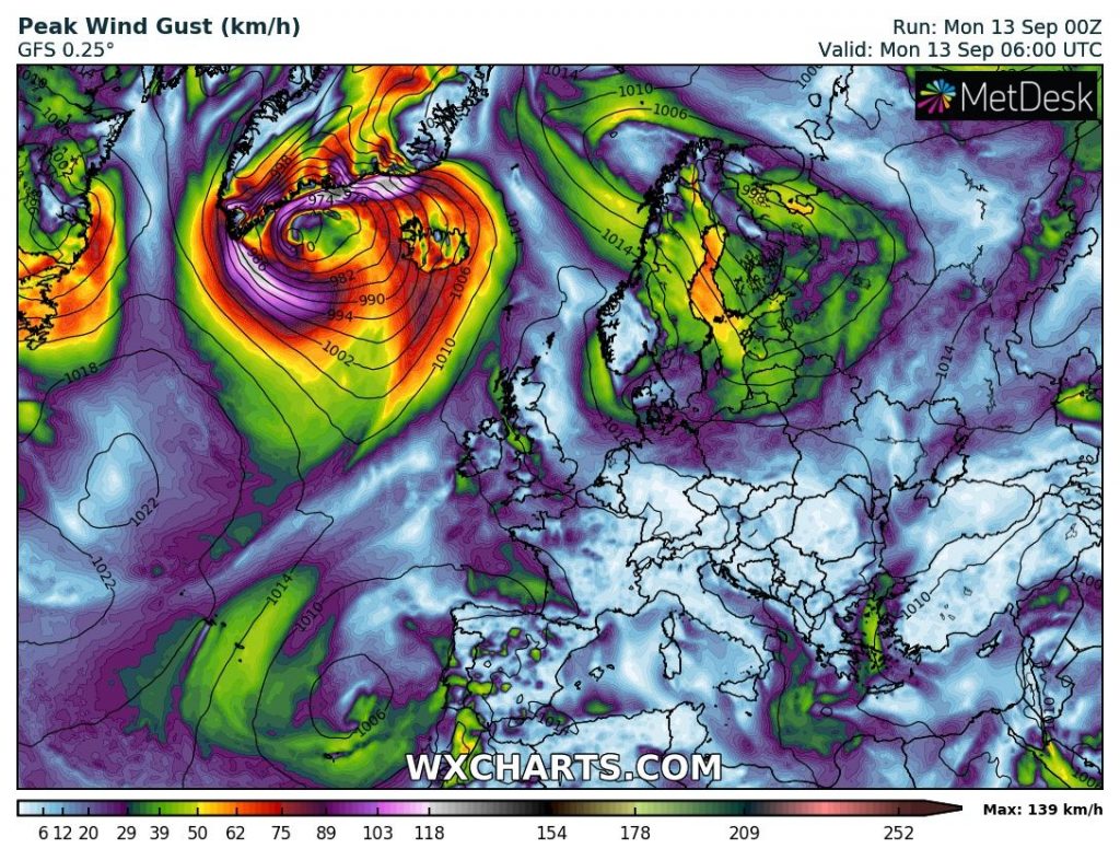
As you can see on the map above, Greenland and Iceland will be hit by a very strong storm in the coming hours. Wind speed up to 150 km / h. Combined with heavy snowfall, the weather in the region will be very unfavorable for some time. It is noteworthy that in the following days Hurricane Larry (which was already low) will affect the weather in Scandinavia. In the northwest of the region, we are also expecting snowfall and winds approaching 100 km/h. These events will coincide with the general cold that awaits Europe in the near future.
Calm in Europe in the second half of September
I’ve been a bit worried in recent weeks that summer has settled a lot in the northern hemisphere. I have already written about the high temperatures on the glacier. Not so long ago, more than 28 degrees were determined by thermometers in the British Isles. The temperatures are definitely too high for the north of the continent in September. Glad, the weather is starting to get back on track. Unfortunately, this will include Great cooling will also hit central Europe. I think 30 degrees in September is too much for our area, but the pleasant frosts announced over the past decade also do not impress me (you will not please such a person).
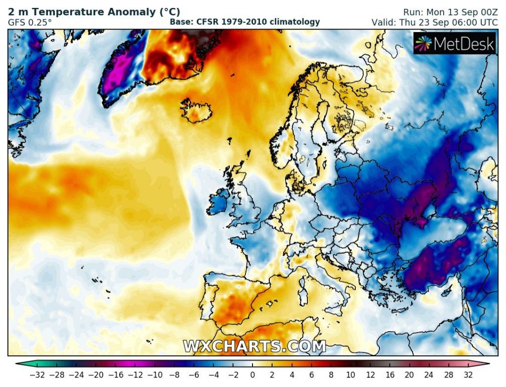
It turns out that the lull after September 20 will be really extensive. I will write about frost and even frost in the country in a separate entry. However, the above graphic shows that very cold air masses will reach deep into the south of the continent. A very negative temperature anomaly will prevail, for example, in the Black Sea basin. Here, in the higher parts of the mountains, frost can also occur.
All in all, Hurricane Larry will cause a lot of turmoil in the north in the coming days. In Greenland and Iceland, we will be dealing with blizzards that can drop up to two meters of snow. There will also be wind gusts of up to 150 km/h. In the following days of September, residents of Central and Eastern Europe should also prepare for changes in the weather. It will get colder. Frost will appear. Some models even see a slight frost in the area.

“Food practitioner. Music junkie. Avid troublemaker. Hipster-friendly creator. Social media lover. Wannabe pop culture fanatic.”